Both locations are misnamed: the Aztec Emperor Montezuma had absolutely no connection to the sites nor the ancient peoples that lived here.
When European-Americans first observed the ruins in the 1860s, by then long-abandoned, they named them for the famous Aztec emperor Montezuma in the mistaken belief that he had been connected to their construction

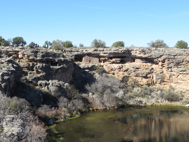
First we will take a quick look at Montezuma Well, it is about 6 miles upstream from Montezuma Castle. It is a fascinating place.

This is a map of the Well and associated trails. The trails are paved for the most part. There are natural limestone steps that take you up to the edge and a smooth concrete path that continues back to the parking area. The distances are short and periodically marked with informative signs identifying different plants or trees.

The Well measures 386 feet (118 m) in diameter from rim to rim and contains a near-constant volume of spring water even in times of severe drought.
The water is highly carbonated and contains high levels of arsenic, hence is unfit to drink.
Montezuma Well's steady outflow has been used for irrigation since the 8th century. Part of a prehistoric canal is preserved near the park's picnic ground, and portions of the canal's original route are still in use today.
The constant supply of warm, 74 degree water was the life-blood of the people who made their home here.
Over 1.5 million gallons of water flows into the Well every day.
This water enters an outlet through the side of the Well near the end of the trail into the Well and flows through over 150 feet of limestone before re-emerging from the outlet into an irrigation ditch on the other side. Sections of this ditch date back over 1,000 years.

If you look across the well you can see rock structures built up under the overhanging edges.. Here is a closer look at those structures that were used for living accommodations or storage by the early people.

There is a trail that leads down to the waters edge. When we visited, there were several school buses of kids out on a field trip. They were all over the place. One sign said there were 117 steps down on the trail down to the lake.

Here are some of the tourists walking along the concrete paths.

We had mentioned that different plants were identified along the trails. Here is a Hedgehog Cactus.

This is the sign with some information about the Hedgehog. Each of this type of informative sign had some amount of damage. The Arizona weather certainly wreaks havoc on the signs. Some of the bronzed and more permanent types of signage fared better but all show deterioration from the sunlight and weather.

Now we will move over to Montezuma Castle for a quick look around.

The castle is a 20-room mud-and-stone structure built about 80 feet above the valley floor in a cavity in the limestone cliff. It’s estimated that the Sinagua People built the castle somewhere between 1100 and 1350 A.D.
They erected the structure about one-third the way up a 150-foot limestone cliff high above Beaver Creek. The dwelling’s walls were made from limestone and mud mortar. Large beams covered by smaller beams were used to frame the roof, which was then covered with thatch and mud.
Stone axes were used to harvest the trees (usually sycamore, alder or ash) used to make the larger beams.
The walls of Montezuma Castle were two feet thick at the bottom and narrowed to one foot thick at the top. The ceilings were six-feet high and the T-shaped doors are five feet high. The doors were kept low and small to preserve heat in the room.
The Sinagua used Montezuma Castle not just as their home but as a community center where they held community meetings, worked, stored crops and seeds.

There is this wonderful path that leads from the Visitor Center to many viewing points of the castle.
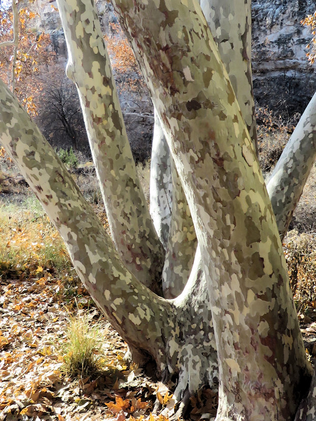
Some of the beams used in construction of the castle are Arizona Sycamore. Many of these trees grow quite large. Here are some smaller examples. Notice the pattern on the bark.

Since you cannot go into the castle they have this scale model using a cutaway technique to show the interior. There was a recording that accompanied this display describing what might have gone on in the castle. The Sinagua who lived here did not have any written history so much of our understanding is determined from an analysis of artifacts found at the castle or derived from verbal history from other indigenous peoples.

We had mentioned the Sinagua, here is some information about those ancient people, keep in mind, they had no written history:
The name Sinagua was coined in 1939 by archaeologist Harold S. Colton, founder of the Museum of Northern Arizona, from the Spanish words sin meaning "without" and agua meaning "water", referring to the name originally given by Spanish explorers to the San Francisco Peaks near Flagstaff, the "Sierra Sin Agua".
Scholars are uncertain about the origins of these prehistoric people. Equally compelling is the mystery why they vanished. It has been discovered that they were peaceful village dwellers, strongly established in the rites and rituals of living in the Verde Valley. Timed to the seasons and fueled by the trades and rituals, the life of the Sinagua persisted for more than three centuries. But, now, artifacts and ruins are all that remain.
It is fascinating and unknown why they and apparently all the rest of the ancient people vanished in the early to mid 1450's. Click Here for an article regarding the Sinagua.
We hope you enjoyed this brief look at the Well and the Castle. They are both quite fascinating places to visit. Be sure and stop by each of them when you are in the area. They are fairly close together not far from the town of Camp Verde and only a short distance from Sedona.
Let us know if you have any questions or comments.
All the best – George & Deanna
Lovely pairing of the two sites. Thank you so much!
ReplyDelete