About 55 miles to the east of where we are staying here in Camp Verde Arizona is Tonto Natural Bridge State Park. This map provides the location within Arizona. It is South and East of Flagstaff and North and East of Phoenix fairly close to Payson, AZ.
On Hwy 87 between Pine and Payson, about 10 miles north of Payson you will see this entrance sign. The natural bridge is located about 3 miles to the west of the highway.
This sign is right before you head down, and we mean down into the valley where the bridge, Pine Creek, and the visitor center are located. This sign is by a drop off area for travel trailer, they do not recommend you bringing your trailer down this hll.
Down we go - brakes don't fail me now. The area circled in this image is the parking area at the bottom of the decent. The road was not as bad as one would have you believe, it was a good surface and wide enough with guard rails.
We decided however that we would not try the road in icy conditions, too old for that much fun.
We are safely down the road and have paid our entry fee. It is a State Park and they charge $7 per adult for an entry fee. Fortunately the two dogs were free and they are allowed on part of the grounds as long as they are on their leash.
The large building in the photo is called Goodfellow Lodge and was built in the 1920's. It also contains a small gift shop and some offices for the State Park, it is a neat looking building.
The lodge can be rented by groups for reunions and other gatherings. It has 10 finished bedrooms (some with private bathrooms, others share communal facilities) as well as a basement suite with private kitchenette.
The first floor has a dining room with picnic-table seating, a fireplace and large kitchen. Overnight guests must stay in the area surrounding the building after the park closes. Trails and the creek area are off limits after hours.
,
Here is a map of the area around the natural bridge. There are four access points for viewing and several trails that will take you down and through the bridge for close up viewing.
This is just a view across Pine Creek to provide a feeling for the terrain. We are in an open valley that has substantial hills rising on each side.
Here we are at Viewpoint 1 looking south into the natural bridge. A placard at this location provides the following information:
In front of you, one of the world’s largest known travertine bridges, arches over the clear waters of Pine Creek.
The natural forming bridge is 150 feet wide, 183 feet high, and 400 feet long.
It is estimated that the volume of rock is 200 million cubic feet. This geologic wonder is the result of thousands of years of nature’s handiwork and it is still growing.
The travertine here is formed by deposition of calcium carbonate in small amounts. A constant flow of mineralized water from a perennial spring supplies the ever-growing travertine formations.
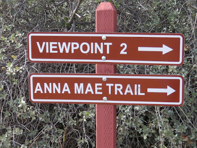
We have walked across the bridge and over to Viewpoint 2 which looks back across the creek and bridge to Viewpoint 1. We thought this was an interesting rock formation on the side of the wall above the. creek.
As mentioned earlier there are several trails that lead down onto Pine Creek. One of the trails is Anna Mae trail that will take you directly under the natural bridge.
Unfortunately the trails were closed due to the recent snows and resultant muddy conditions. We were able to get to Viewpoint 2 but not down any of the four trails that lead further into the creek and under the bridge.
This is the information regarding the Anna Mae Trail. There are similar descriptions at the start of the other trails. It appears they are not for the faint of heart.
Here, from the Arizona State Park Web Site is a description of the four trails. Dogs are not allowed on any of the trails.
Pine Creek Trail is about ½ mile long (400 feet developed - undeveloped in the creek bottom), leads to the Pine Creek natural area. Hiking shoes are recommended. Follow the arrows. Allow one hour.
Waterfall Trail is about 300 feet long, ends at waterfall cave. Uneven steps. Allow 15–20 minutes.
Gowan Trail is about 2,200 feet long, down and back leading to an observation deck in the creek bottom. The trail is steep and rough. No trash cans. Hiking shoes are recommended. Allow one hour. The footbridge to the observation deck is currently closed.
Anna Mae Trail is about 500 feet long and leads to Pine Creek Trail and the Natural Bridge. Allow one hour.
This is looking across at the Anna Mae Trail from Viewpoint 1 as the trail winds down by Pine Creek. Looks to be lots of stairs.
Here is some of the runoff from the spring that runs year round. We will see where it falls over the side of the Natural Bridge in the next image. It flows at about 300 gallons an hour constantly, year round. The minerals in the water reacted with the minerals in the soil to build the bridge.
In chatting with some of the park personnel the best guess is that the Natural Bridge is about 5,000 years old. It started as a massive rock slide that crossed Pin Creek but did not block it, the creek flowed under the rocks. The high mineral quality in the spring water formed the travertine that is the bridge we see today.
The is the view looking into the Natural Bridge from the south. We are at Viewpoint 4. You can see the waterfall from the spring on the left in this image.
Looking over the side of the canyon wall we see a trail that follows the wooden pathway along the creek.
Since the weather did not allow us to descend down to the creek bottom we borrowed this image to show you the size of the bridge. Note the people in the lower right hand corner. This is quite an impressive natural bridge.
At various points along the trail we saw these flat rocks with different colorful animals painted on them. This is a well done Cougar, there was also a Bobcat and Javelina.
It is close to winter here and there were not a lot of birds around. Here is a Woodhouse’s Scrubjay , we saw a few of them round.
As we were getting ready to leave we saw this tree. It appears they have pruned it trying to form a better bonsai shape. Perhaps they got a little over zealous with their pruning saw. Maybe in the spring it will fill out with new limbs and lush green leaves.
Here is the road going out. It is the very same road we came in on. There is only one road in and out. We are ready to climb that hill and head for home.
We hope you enjoyed this abbreviated look at Tonto Natural Bridge. Unfortunately we did not get down under the bridge for different perspectives, perhaps on our next visit. The weather folks say there is more rain and snow on the way so it is unclear if we will get back this trip, if not, certainly later.
Please let us know if you have any questions or comments.
All the best – George & Deanna


