Saturday, June 22, 2019

Looking Around and a Few Birds

Here are a few images of places to see around here and some bird friends that will be awaiting your arrival. Be sure and come up here to the northern part of Washington State - It is a Great Place.


This Ring-necked Duck actually has a ring around it's neck. Not very often do we get a chance to see the ring for which it was named. We were surprised at how much of the neck the ring covers. And no the grass frond across his back is not a duck leash to which he is tied for the picture, rather it is part of the natural environment and was going to be part of his lunch.


At Teal Lake, along one of the back roads we traveled there were Bufflehead and chicks. It seemed to be a popular lake for Bufflehead as there were several batches of moms and kids on the lake. One group, a bit more distant, had twelve ducklings.


We had mentioned the town of Chesaw in an earlier post. These are two of the main buildings in Chesaw, a Tavern and place to eat is on the left and General Store on the right. There is also a small set of gas pumps associated with the store and there is a mercantile about a block up the street and a couple of buildings associated with the Rodeo Grounds. There are not many businesses in Chesaw. The name Chesaw was derived from an early Chinese resident named Chee Saw who had a trading post in the area.


Across the road from the tavern are the Rodeo Grounds. Each July 4th they have a rodeo. The lady in the store, whom we chatted with, indicated that last year they sold over 5,000 tickets and that attendance count does not include the children under 10 who get in free. We had heard it was a really big and wild time. The big dance is on July 3rd and gets things kicked off.


We have seen a lot of swallows in the area, they are everywhere. This was a decent image of two of the swallows resting from the foraging flights.


Molson is a historic town up in the hills to the east of Oroville. There is a museum there and quite a few buildings along with a number of homes and residences. The large brick structure in the right side of this image is an old school that was built in 1914. There were a lot more people in Molson back then.


This was in front of a wetland area as we came down the hill and before we turned towards Molson and someone there has a good sense of humor. I don’t think there is even a lifeguard in the nearby area much less on or off duty


Molson is close to the border with Canada. A short distance up the road from Molson is this sign marking the original site of Sidley. This also demonstrates a dramatic difference between the Southern and Northern Borders. Directly behind this sign is Canada. There is no border crossing right here but we are told there are motion sensors in the area so it is best to stay out. We have seen some number of Border Patrol Vehicles but nothing near what is evident on the Southern Border.


The gravel road, from just a little past Molson for quite a ways, follows an old railroad grade from the early to mid-1900. In many place they routed the road off of some of the grade while in places such as seen here the road just went through the old cut in the rocks. It is narrow but certainly passable.


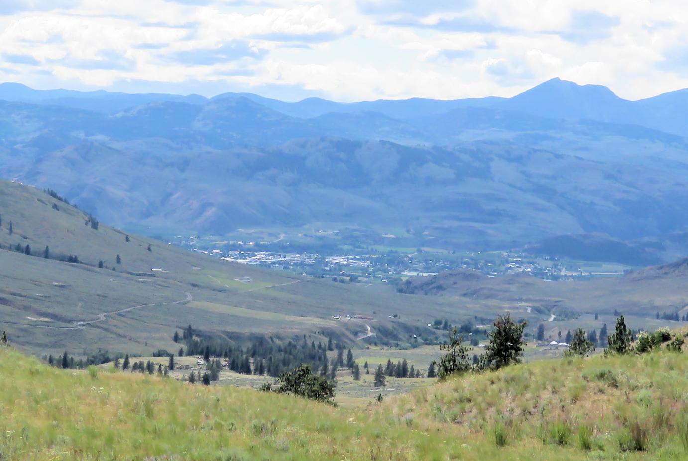
We paused along the road to look down towards Oroville. We climbed quite a bit to get up to Chesaw and Molson, now we are heading back down. There is a lot of rolling somewhat steep grasslands and many extensive forests up higher.


We are always surprised by the bright blue bill of the male Ruddy Duck. On one lake there were a lot of Ruddy’s and they did not seem at all bothered by our presence. Many were right next to the road and stayed there when we stopped to take pictures.


This is a view across Lost Lake which is about 6 miles above Bonaparte Lake. There was a pair of Common Loons on the Lake with two chicks. There is also a great Forest Service Campground next to the lake and some number of homes scattered around. This is almost 4,000 feet in elevation so you would snowmobile to your home in winter.


We were out looking around on Friday and found this Meadowlark. It had some bugs in its beak and was heading to the growing family to provide a snack. What surprised us was, as it was sitting on the post, it started singing away, that distinct Meadowlark sound even with all those bugs. This was certainly a multitalented Meadowlark.


We have seen a lot of old cabin type structures in our travels here in Okanogan County. This was very close to the Canadian Border and unfortunately no information was available at the site. Throughout the county the Okanogan Historical Society has placed many placards with information describing various sites and or events. They are very well done and extremely useful. This old cabin seems to have been here for a very long time.


We saved a decent image for last. When we drove from Chesaw to Molson we went past Fields Lake, one of our favorite birding spots. The wind was blowing very hard, it was cold and we concluded we would not see much. Then we noticed this Red-naped Sapsucker. The pair were feeding young and went in and out of the cavity quite frequently. What is not seen in this image is that about two feet below this nest hole is a Tree Swallow nest, in the same tree and they were busily feeding young as well. We never could get them both feeding in the same image. The Tree Swallow would fly into the small hole at full speed, amazing to watch.

The Okanagan County and the wildlife around here are both fascinating and amazing. The food is great at some of the small back country eateries and the history of the area is worth researching. Be sure and make the time to get up here for a thorough look around, it will be well worth the effort. We rather much like this country.

Please let us know if you have any questions or comments. All the best – George & Deanna

Friday, June 14, 2019

Looking for Loons

We came to the north of Washington State for several reasons. We had never spent much of any time in this part of the state, it appeared from research there might be some wonderful country here to explore, and we might find some interesting birds including Common Loons. So let’s take a look around for some Loons.


This is a map of our route on June 13th. The circuitous route ended up being about 105 miles in total. The route passes through some fascinating country from extensive apple and fruit tree orchards along the Okanagan River to open, rolling grass lands, to lush conifer forests.


Our first stop was at Bonaparte Lake. There is a Resort located on the lake as well as a Forest Service Campground on the west end. About half of the sites in the campground can be reserved while the remainder are first come first serve. There is water available at the campground and pit toilets but no other amenities. It seems a nicely done campground in decent condition.


We stopped first at the little boat ramp in the campground and saw this female mallard shielding her young from the warm sun. There ended up being 7 ducklings hiding in the shade.


At one point the ducklings decided to disperse and here is mom and one of the kids going for a walk. We thought this a cute image with both of them in lock step.


Here we are at the Resort. It would be considered rustic in nature. There are cabins and boats for rent, gasoline available, and RV sites with full hookups and a restaurant in the main building you see here. The food in the restaurant was absolutely fabulous as we found out. Well worth the decision to have lunch here.


We are on the back deck waiting for lunch to be served. The cabins are called “Rustic Cabins”. The communal restroom is behind these little cottages. They are, as evidenced by the image, close to the lake shore.

While we were eating lunch and admiring the view of the lake this Tree swallow joined us. It did not seem interested in begging for some handouts rather needed a rest from all the flying and foraging for bugs in the warm sun. There were a lot of swallows and swallow houses. We saw Violet Green and Barn Swallows in addition to the many Tree swallows.

Off to the left of this image, as the lake extends west towards the campground, there is a shallow area surrounded by open water. The shallow area has a bunch of reeds growing and we heard a Loon calling from that area. We asked the young waitress about the Loons and she said they are nesting in that area and can be seen swimming out in the lake in the early mornings and evenings. It was really neat to hear the loon calling.


We headed back to Highway 20 and over to Old Wauconda and up towards Bodie. Bodie is just a Ghost Town and there is not much of anything at Old Wauconda. We stopped at a wide spot, heading up towards Lake Beth to look for birds and found this Willow Flycatcher. It did a decent job posing for us so we took it’s picture.


Beaver Lake and Lake Beth are adjacent. There used to be a campground at Beaver but it is closed. There is a campground, quite extensive, at Lake Beth. It is a no service other than water campground but has a lot of sites. Looking at this map image we found the Loons on the farthest east end of Beaver Lake. Birds do move so they might not be there later.


Here is the area of Beaver Lake where the Loons were located. You can actually see one as a white dot out in the center of the lake in this image.


Here is a Common Loon and its two chicks. They were swimming around and gathering grasses for food.


Often one or the other adult would dive and come back to the surface not very distant. They would then swim together for a while before one or both of them would dive again.


This shows all four of the family. They swam around quite a bit and the kids seem to keep up without any problem. But then I am sure the adults were keeping them close.


This last image just provides another view of the family. We watched them for quite a bit with no other person very close. They did not seem bothered by our presence. It was most fascinating to watch them.

We hope you enjoyed following along for our Looking for Loons. We had a great lunch, found some neat birds, and had a great time, wish you could have been here. When you do come up to this part of Washington be sure and head out on your own adventure “Looking for Loons”

Please let us know if you have any questions or comments. All the best – George & Deanna

Tuesday, June 11, 2019

What We Have Been Seeing

This post is just a random collection of images and comments. These are some of what we have been seeing in this part of the country as we travel around.


We see a lot of Redhead Ducks on the various ponds and lakes. This is just a fun image with a pair, male and female, of Redhead and three turtles just sunning themselves on a log in the warming sun. Not sure what species the turtles might be.


We stopped to look at a historical site on one of our jaunts around. This flower was growing on a big rock adjacent to the site. There were several of them on the rock. Our friends Rodger and Ginger identified the flower as a Bitterroot. It is a really pretty flower.


There are numerous lakes and large rivers around here. There are also a lot of Osprey. This nest was out in an apple orchard not far from Spectacle Lake west of Tonasket which is a small town south of where we are.


We call this picture “It Might Rain”. We were coming around the end of Palmer Lake heading back home. The rain clouds were falling. We missed most of the moisture.


We thought this sign humorous and a good play on words. There is a lot of cattle ranching around here and a lot of horses. The message is trying to get you to use certified weed free hay when feeding livestock and transporting the critters around. They don’t want to transport noxious weeds.


This is orchard country. There are vast tracts of apples and cherries and a variety of fruits and other things that grow on trees. It is early in the season and with the cold weather in February the fruit ripening is a little late. We are hoping to get some Rainer cherries before we are scheduled to leave.


In traveling around, we can quickly go from the low country of open fields and far reaching views to higher mountains with more closed in conifer forests. This is a view along Beth Lake showing a higher elevation lake and the gorgeous scenery.


In contrast to the above image, here is one view of Fields Lake that shows the more open grassland terrain. There are lots of birds in and around Fields Lake. It appears to be surrounded by private land but we did see two kayakers on the lake during one of our visits.


Just as we leave Fields Lake we have this vista. It gives one a good feel for some parts of the country side. The brown field in the foreground has been plowed in preparation for planting.


Here is a Western Wood-Peewee or maybe a Willow Flycatcher. We are trying to determine which species. If you get a chance, let us know what you think it might be and why you have made that determination. We find it fun to try and figure out "What bird is That?".


This is the Similkameen River that comes out of Canada and connects near here with the Okanagan before heading south to join the Columbia. This image was taken about 3 miles upriver from where we are staying here in Oroville. This river runs right behind our trailer and it is a calming influence to watch on a quiet evening.


We ate lunch at a Mexican Restaurant called Rancho Chico in Tonasket. We thought it was quite good food, well prepared and nicely presented. They have very colorful decorations all around the establishment. This is the door to the ladies restroom. It is quite eye catching and well done.


We took a drive south to Conconully Reservoir for a look around. On a side road we found this Dusky Grouse. It was fairly cooperative as we tried to get its picture. We don’t get to see grouse that often, we shall trying looking for them more.


About 8 miles from here is Wannacut Lake. It is about 2-3 miles long, spring fed, and almost 200 feet deep at its deepest point. There are several homes around the lake but not overly crowded. It seems to be a great spot with one resort and a public fishing access point.


Here is Mom and the Kids. This is a Common Goldeneye with 8 young ones in tow. This image was taken at Beaver Lake up in the conifers. Hopefully they will all make it to adulthood.

We hope you enjoyed this brief look at what we have been seeing. This is really fascinating country, a very diverse collection of habitats within close proximity to our present location. You really should come up here and take a long look around, great place.

Please let us know if you have any questions or comments. All the best – George & Deanna

Friday, June 7, 2019

A Look Around the Countryside

For those of you who might not be familiar with Washington State and where we are located, here is a quick look at our current home in Oroville, Washington, which is the point highlighted in yellow. Seattle is in the lower left, Spokane is in the lower right, Vancouver, BC is in the upper left and the solid line across the upper part of the map is the border with Canada.


For this blog post we will take a tour around some of this beautiful country. There are lots of lakes and mountains here. It is a really neat place and so far we have not seen all that many people. That more than likely will change as the summer progresses.

Here is a map of our route. You can see the Canadian border towards the top of the map. We are almost in Canada and Verizon,our cell service provider, thinks we are in Canada and wants to charge us a bunch of money for roaming out of the states. We have not gone into Canada, so we needed to discuss the geographical limitations of our travels and the economics associated with that travel with Verizon. Hopefully they won’t charge us extra, we shall see. But I digress.


Though the route is a circuitous one; we will concentrate our comments on the south west portion, the Sinlahekin Valley and wildlife area. Though we did not start in Loomis it is at the northern end of the Sinlahekin and this sign is found there. Loomis is a small town one general store and several homes and lots of cattle. It is a beautiful area about 16 miles west of Tonasket.


Before we got out of Loomis we saw this entry gate to the Spear Ranch. We thought it was a wonderfully well done gate.


OK we are on the road that heads basically north south down the valley. Our southern terminus is Fish Lake but there are many lakes and sites to see between here and there.


There is a headquarters complex for the management of the Sinlahekin. It is operated by the State Of Washington for the benefit of all. This sign is just off the road before you get to their buildings.


This lush green meadow is at the start of the Sinlahekin. The terrain was a mixture of sparse pine trees, meadows, high mountains, and lakes.


One of the lakes we encountered, and we won’t bore you with them all, is Forde Lake. The sign basically says the lake was formed in 1949 to promote fishing and irrigation and has been used extensively for fly fishing. There was a great variety of waterfowl on the lake including ruddy ducks and wood ducks among other species.


This a broader view of Forde Lake. It did not appear to be very deep and had a lot of reeds and brush around the edges, great habitat for waterfowl.


Here we have a view of the sides of the valley. The road follows along the valley floor and is accentuated on each side by these high rocky cliffs.


We stopped and looked north along the road. Shortly after you leave Loomis it turns to gravel as you see here. It was in good condition and not full of washboard. We are guessing it will get a lot of use in the summer months.


This is the south end of Blue Lake one of the larger lakes along the route. There were people camping at many of the lakes in what would be considered primitive campgrounds. They had numerous pit toilets along the way but limited other facilities. If you camp here, you need to have everything with you. Blue Lake was a beautiful Lake as were most of the others.


This shows the north end of Fish Lake. It parallels the road being restricted in width by the ridges of rock on each side. Blue Lake was of a similar configuration and geographical constriction.


We are looking south down Fish Lake. You can see the road that heads up and out of the valley in the left side of this image. Just as you get to about the middle of Fish Lake the road changes from gravel to pavement and is paved out to the highway.


We stopped at the bend in the road and looked further south. The Sinlahekin continues on but the road takes us away from the great scenery and wonderful lakes.


We didn’t want to bore you with a bunch of bird images but felt the need to include one. This is an Eastern Kingbird. We have seen a lot of this species in our brief travels around here.


Here is an image I almost forgot, must be getting old. It is of Deanna delivering a scoop of ice cream in a cup, one for each of us. It was from the only store in Loomis and quite tasty. The scenery is beautiful but we must have some sustenance.

We must apologize for the lack of sunshine and brightness in these images it was an overcast day and the colors did not show as well is these photos as they should have.

We hope you enjoyed this brief look at the Sinlahekin Valley and the lakes and the scenery that are there. We don’t think the images do the place much justice as it is far more magnificent than these few pictures and our meager words can convey. You need to put this place on your bucket list or whichever list you have of places to visit and get up here.

Please let us know if you have any questions or comments. All the best – George & Deanna