Monday, April 8, 2019

Bear River Migratory Bird Refuge


On our way to Walla Walla we stopped at Brigham City, Utah which is just north of Salt Lake City. Bear River Migratory Bird Refuge, a 74,000 acre refuge, is there and we wanted to take a look. The large, appearing to be new, visitor and education center is visible from Interstate 15. The auto tour loop is located about 12 miles to the west of the visitor center; it is about 12 miles around the loop out through a large wetland area. There are no trees just flooded wetland areas. The gravel surface tour loop road was in decent condition, most of it was very smooth but short sections were rather bumpy.

In early April when we visited, the spring migration was just getting underway. Many bird species were arriving and the numbers of others already there were increasing. The large flocks of Trumpeter Swans had already departed, heading north, though we did see a few in various locations.


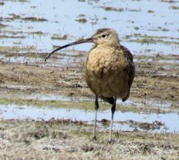
On the paved road before you get to the tour loop we spotted this Long-billed Curlew. The Curlew was by itself just resting in an open field.


We got to the tour loop, slowed down to look for birds and the dominant bird of the refuge came flocking in, the mosquito. We will apologize in advance for the quality of many of the following images. We decided not to roll the windows down to take pictures, we only had 5 cans of mosquito repellent with us and we were afraid we might run out. When the gentle wind was blowing the mosquitoes moved to the downwind side of the truck and congregated there by the hundreds. Hence the windows stayed up.


We were fascinated by the numbers of Cinnamon Teal. The largest numbers of water fowl that we saw were the Cinnamon Teal and the Northern Shoveler. There were many of both these species and when we were there the biologist’s count displayed in the visitor center confirmed this fact.


We saw lots of small flocks of Yellow-headed Blackbirds as we drove around. No huge congregations as we had seen in Arizona but 15-26 here and 11-19 there. There were many small flocks in multiple locations.


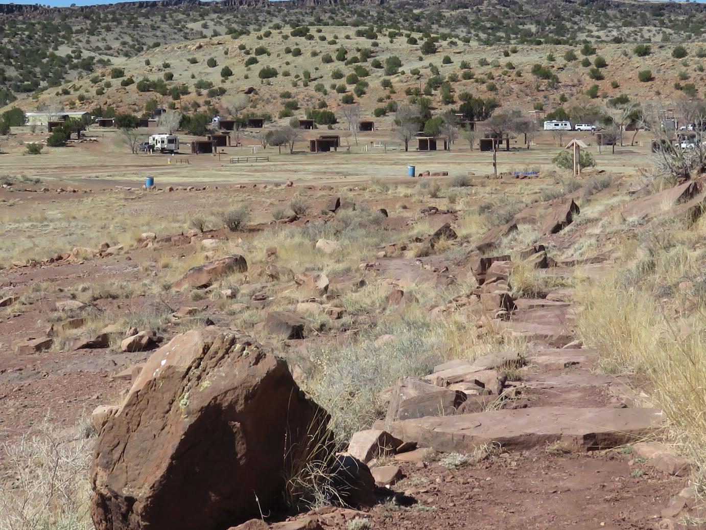
Here we are trying to provide a feel for the refuge habitat. It is flat open marshland. We are looking to the North West and flooded area continues on and on. 74,000 acres is a lot of land.


In one of the water channels we found this Red-breasted Merganser. The Merganser was by itself and not interested in posing for pictures.


Here we have an American Avocet. There were many of them in the shallow flooded area. Apparently the Avocets nest here. We also saw Black-necked Stilts but they were a bit far away for a decent image.


There were many gulls in the area. Here is a Franklin’s Gull noted by the distinct black head. There were also Ring-billed and California Gulls though not huge concentrations that we could see. Just a few here and a few there scattered about.


Probably the most common non-mosquito bird was the American Coot. They were everywhere in large numbers. To control their population I have long thought that McDonalds should serve Coot McNuggets. But nether that neither idea nor the taste has caught on as of yet.


Here is just another look around the refuge. We are looking towards the east. The mountains rising in the distance are directly behind Brigham City and provide a nice visual back drop. They are called the Wellsville Mountains, they are 14 miles long and 5 miles wide, and considered one of the steepest small mountain ranges in the Rocky Mountains.


This bird surprised us. We thought the water might not be deep or productive enough to support American White Pelicans but we did see several on the tour around the refuge. No large numbers but still surprising. We also saw several Canvasback Ducks which are normally associated with deeper water but maybe they were just passing through on their way north.


Here is a Western Grebe. They are here in bright breeding plumage. Note how the black cap on the head extends below the eye. At Bill Williams NWR in Arizona you can see a lot of grebes, both Western and Clark’s. In the winter the black cap line is not as clearly defined and when counting Grebes there they often just merge the two together as the distinction between the species become more difficult due to a lack of plumage variations.


Here is a Clark’s Grebe. Note the bright yellow bill and the distinct line above the eye separating the black on the head from the white on the face.


Here are two Clark’s Grebes. We had seen them, just prior to taking this image, do their courtship dance, where they stand up and run across the water side by side. Unfortunately we could not get that activity in a photograph. They just won’t listen to our “Dance Commands”.


This is the gravel tour road. It is not very wide and only one way. There does not seem to be much traffic so passing people or being passed was not an issue. There are various pullouts where you can park and watch the wetlands and waterfowl. There is also a viewing tower at the start of the tour loop that gives you a panoramic view of the area and allows the mosquitos to chew on you at will.


On the way back to the visitor center we noticed this interesting pair. There is fencing visible in the foreground and we decided just to leave it in the image rather than climb over or under the fence to get a clearer picture. The large fellow might not have a pleasant disposition and we did not know if the dog would bite. There was no “Beware of Dog” sign but then looking at the dogs' associate, the dog was probably the least of our worries. It is best to just stay away.

We saw many more bird species than the few we pictured here. We just wanted to give you a little glimpse around Bear River Migratory Bird Refuge. It is a fascinating place, lots of birds, and a wonderful tour loop. It will be fascinating to see it at a later time of year. Be sure and stop by there when in the area.

There is a lot of information out there about Bear River, just search on the Internet for a vast number of images and copious amounts of information
As always let us know if you have any questions or any comments. All the best – George & Deanna

Kodachrome Basin State Park


We stopped in Panguitch, Utah on our trek north and took a side trip over the Kodachrome Basin State Park. It is about 45 miles to the east from Panguitch and past Bryce National Park.

How did Kodachrome Basin get its name? - We were out hiking in Kodachrome Basin State Park and stopped to chat with a young fellow who appeared to be about 28-30 years old. He stated that this is a beautiful place, a comment with which we agree. I said we had been here about 26 years ago and at that time we used Kodachrome slide film to take pictures, the film for which the Basin was named. He looked puzzled and asked what that was all about? I explained the Kodak Corporation and the film that was used for pictures and slides before digital. He said "Oh, I wondered where the odd name "Kodachrome" came from.

Ah the young and the digital.


This was an image taken from the vehicle as we passed through a canyon heading east. There was a fair amount of snow at the higher elevations. On the road over you traverse a pass marked by an elevation sign indicating 7,777 feet. There was a fair amount of snow in that area. We did drop down as we got further east and there was no snow in Kodachrome.


One of the first things you see in the Basin is the large red sandstone cliffs. They are quite beautiful and truly majestic. You enter the park and there are a couple of roads that take you to the various sights and scenery. There are also campgrounds in the park, some with full hookups, some partial hookups and some dry camping. We could easily see how this park could get really crowded in the summer.


There is much more than just red sandstone. The spire in the center of the image, amidst the junipers and sandstone was apparently made of harder rock and resisted the weathering and erosion.


Here is another larger spire that stands very high. The longer term forces of erosion have made a huge number of visible impacts throughout the basin.


This image shows an interesting collection of spires and sandstone formations. There are lot of rock layers and various forces of erosion at work here.


This is a closer examination of the previous image. Erosion has left the cap on the spire and again we can see the contrasting rocks.


About in the center of the basin you will see this laundromat. There is a bunk house and some showers associated with this facility. The campers do need to keep their clothes clean and somehow the term “Red Dirt Wash and Dry” seems very appropriate for this location.


As we headed out to a formation named Chimney Rock we saw this large rock outcropping that was highlighted in the sun. The hoodoos of Bryce are visible in the distance.


We decided to take the boys on a hike to Shakespeare Arch. It is down a road to the east and not located directly in the basin but certainly nearby. This is an image of the well-worn dirt trail that takes you to the arch.


This is a view of the incredible scenery that is visible everywhere. There are also a lot of old gnarly juniper trees along the trail. It is fascinating country  


Here is Deanna and the boys along the trail. It was smooth soft dirt all the way. We checked, you were allowed to take the bays anywhere in the State Park. That has not been the case in other Utah State Parks. Good exercise for them.


Here is the arch. It is in the upper left corner of the image and kind of hides. It is not nearly as dramatic as most of the formations in Arches National Park but it is an arch nonetheless.


These formations almost look as if they are melted. The forces of erosion are hard at work here.


This is just another look at the hoodoos of Bryce. It is a ways off but still clearly visible.


We are driving back now and saw this fascinating contrast of structures and formations. This was almost to Canyonville which appeared to be the nearest town to Kodachrome Basin. It certainly was not a big town but located in fascinating country.

We hope you enjoyed a brief look around Kodachrome Basin State Park. It is a wonderful place and our few meager images do not do it justice. If you are in Utah looking at Bryce NP or any of the other many Parks found there, be sure and stop by Kodachrome Basin for a look around, it is definitely worth your time and effort.

As always let us know if you have any questions orcomments. All the best - George & Deanna

Thursday, April 4, 2019

Pie Town - New Mexico

We heard from some friends, Mic and Carol, that we should stop in Pie Town, New Mexico and have a look around and enjoy a piece of pie. We were staying at Lyman Lake State Park and it was only about 88 miles through some rural country so we decided to go take a look.


Here is a map that shows our journey to Pie Town. Being somewhat wandering spirits we decided to continue the trek and head towards Datil and then back to Reserve and then return to our home. It ended up being about 255 miles through some fascinating country. You can see interesting places when you wander but we digress, so back to Pie Town.

How did Pie Town in rural New Mexico get it's name and it is in rural New Mexico long ways from no where? According to wickipedia - Its name comes from an early bakery that specialized in dried-apple pies; it was established by Clyde Norman in the early 1920s. Pie Town has been noted for its colorful place name.

There is another joke about how Pie Town got it's name - It is named Pie Town because it is "exactly 3.14159 miles from the middle of nowhere - Pi."


We stopped in Pie Town at the Gathering Place. There are only about 3 eateries in Pie Town it is a very small place. One of the owners said there are only about 150 people that live in the zip code. This place has only been open about 4 years but seems to be doing a bustling business.

Because the winter can be pretty hard here, it is at almost 7,000 feet, we were told that the 3 businesses rotate with being open during winter so there is always one place at least to try the famous pies. Another place is called Pi-O-Neer but we did not stop there, certainly next time.


There are two entry doors to the establishment. One takes you into the cafe side and the other into the pie making room. Here is the room where they craft the wonderful pies.


This lady was busily making pies and I asked if it was OK to take her picture. She quickly replied no saying “I am under the witness protection program”. She then started laughing and said taking the picture was fine, people take lots of pictures.

As you can see in this image they make smaller, maybe 6 inch pies. The owner said that is about the right size for two people. They will make you a full 9 inch pie on a special order, just call ahead. She then went on to say in 2018 they made 17,700 pies which is a whole lot of pies considering they only sell them here and they are not open the entire year.


Here are some pies ready for baking. These are apple caramel.


Here is a board that lists the pie varieties they make. Not all of these will be available every day, they rotate the varieties. They said they have about 36 different types that they make.


Here is the pie we had. They split it for you so there is no arguing about who gets how much. Of course you need to order a dollop of ice cream with the pie. This is a Pumpkin Pecan Custard variety which was wonderful.


Here is the menu board from which you can order lunch. Pies are the main attraction here so the other food options are a little limited.  


This gives you a little wider view of the eating area. There are three large tables with 6-8 chairs each that are communal in nature. Anyone sits anywhere. There is also outside seating available. The kitchen is to the left in this image.


Deanna ordered the Texas chili. It was very well prepared with just a small amount of beans and a mixture of ground meat and sausage. The seasoning was appropriate for the chili but not overly done. The corn bread was a great addition.


This sign is over the window to the kitchen. The ending part you may not be able to read because of the glare from the reflection through the window states “… and the love is free”. Good sign.


This sign indicates it is perfectly fine to carry a weapon in here. You see this type of activity called open carry a lot in Arizona and here in New Mexico. The owner had a pistol strapped on his hip.

He said it was really safe around here and they never lock their house and always leave the keys in their car. He went on to say it is a long response time way out here to get a Sheriff if needed hence the possible need for a firearm.


The doors leading into the kitchen, the pie making center, and out of the café all have these wide moldings. People write their comments, names, initials, or witty sayings on any of the door jams. Adds a little flavor to the establishment


As we left The Gatherin Place we noticed this sign and area to the right as you face the front of the building. They have a small dog park where it would seem you can keep your dog and enjoy your pie at the same time. This seems to be a great concept for dog owners.

We hope you enjoyed this brief view of the Gatherin Place at Pie Town. If you are traversing Hwy 60 in this area of western New Mexico be sure and stop in for a great piece of pie, it is well worth the drive. Now we need to wander.

Let us know if you have any questions or comments. All the best – George & Deanna.

Wednesday, April 3, 2019

Petroglyph Trail - Lyman Lake State Park Arizona


We are staying for a few days at Lyman Lake State Park in Eastern Arizona not far off the border with New Mexico. This image shows a peninsula that reaches out into the lake; you can barely see the water on the right side of the image. The water level is down but rising. The lake partially encircles this peninsula. There is a trail system that wraps around this peninsula and wanders through various parts of the rock strewn terrain. The trail-head, parking area, and informational kiosk are located in about the center of this image at the end of the gravel road.


Here we are at the start of the trail that is just to the left in this picture. There are some petroglyphs located along the trail hence the name petroglyph trail. We called it the flat rock trail for obvious reason that we shall see.


Here are Deanna and the boys eager to start off on the trail.


At numerous points along the trail we find these flat rocks that provide bridges across small but now dry water ways. This is monsoon country and though the landscape does not look like it now, in the summer they will get drenching rains that course down the hillside and run off into the lake.


Another major use of the flat rocks is for stairs. Lots of them as you climb and descend the various portions of the trail. The trail is extremely well done.


Yogi is seen in this picture getting some help from Deanna. He is going on 15 years old and some of the stairs were a little high for his old bones to navigate. He ended up doing remarkably well considering his age and the problems that he has with his hips.


This provides a view of one section of the trail. It is smooth at times and mostly flat rock stairs at others. It climbs and winds to the left in this image.  


You will see this identical sign at two locations, once at the start of the trail and here where a side path leads to some of the petroglyphs. There is another area of extensive petroglyphs located across the lake. We did not have access to a boat, they were not yet running the tours to that area, and we chose not to swim there hence, we will save viewing those petroglyphs for another time.


Here are some of the petroglyphs. Some are faded and a little hard to see in this light. Ancient people chipped away the patina on the stone to form these images. There are several interpretations as to their exact meaning.


A close up of one of the petroglyphs. This one appears to be perhaps a deer?


At the kiosk at the start of the trail there is this sign. It is a drawing of this section of rock art and shows many of the drawings that were not adequately viewable in the photograph.


Did we say stairs? There are lots of them here, no escalators to be found. After the petroglyphs the trail continues on, up these stairs.

We climbed up and continued along the trail. We looked back to the west for a view of the camping area. Our trailer is on the very left side of this image. There are not many campers here at this time. Each campsite that you see here has a little cabana that would provide some reprieve from the summer sun, a heavy seemingly new picnic table, a fire ring for campfires, and a sand area for pitching a tent.. The camping facilities are very well done with bathroom and shower facilities available at different locations.


Up on top now and there are some piles of rocks. Note the layered structure of the rocks.


We could see part of an opening in the rocks above and there was a separate side trail leading to them. Here we have a better view of that opening; you can see that it goes completely through the rocks.


This is just a view of the lake continuing to the north. One of the publications indicated the lake had a surface area of 1200 acres. Obviously that would depend on the drought conditions. We were told the lake had been really low in the past few years but was coming up due to the large snow pack that was starting to melt.


We see the trail continuing on. It is not all stairs and not all flat surface, a mixture.


We have traversed around the corner of the peninsula and are looking more towards the south. The lake extends off into the distance and goes quite a bit further than we can see here. There is a road that traverses the west side of the lake and provides access to the south end and terminates an old Indian Pueblo located at Rattlesnake Point.


Continuing on around the trail we come back into view of the campground to the west.


We are not finished quite yet, there are still a few more stairs and flat rocks to navigate.


This is the last section of the trail. Almost back to the start now. We can see the kiosk located at the start of the trail.


This was just a funny sign we noticed near the parking area at the start of the trail. There is no swimming here now due to the low water level but as mentioned earlier the water is rising, hence the sign will be more useful later in the year..

We hope you enjoyed a brief look at the Petroglyph Trail. It was a fun adventure and we all successfully completed the circumnavigation of all the stairs and flat rocks.

As always, let us know if you have any questions or comments – All the best – George and Deanna